
Introduction
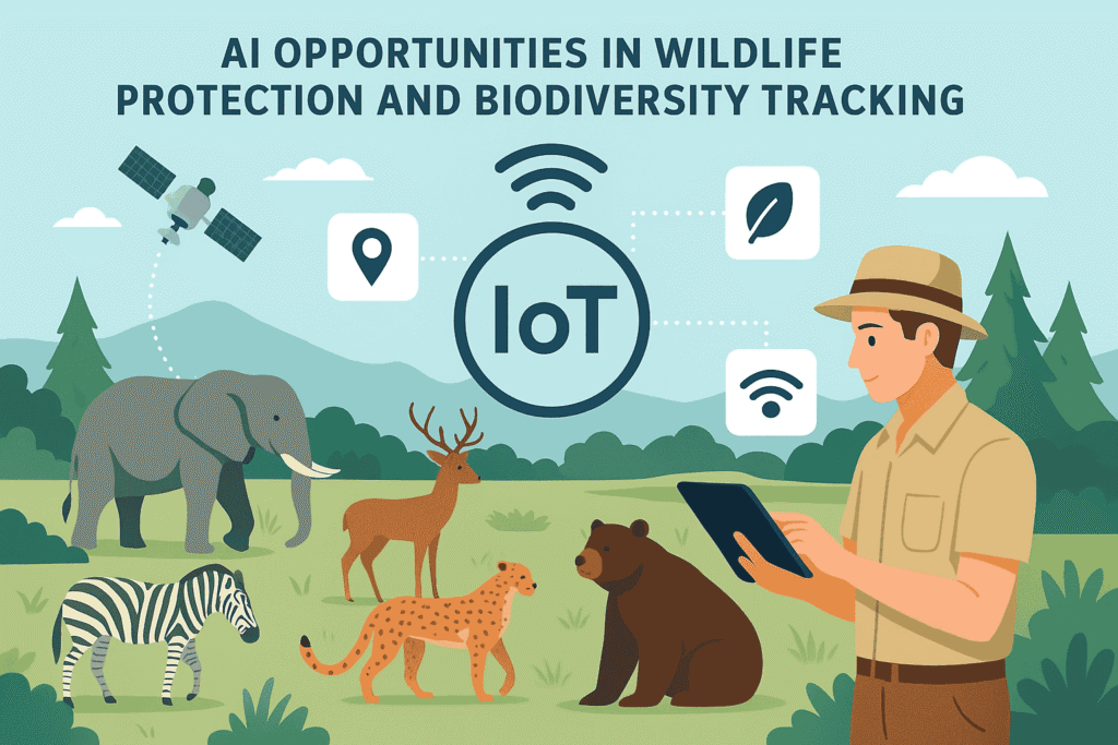
Wildlife protection and biodiversity are crucial for the health of our planet. Biodiversity underpins ecosystem resilience, human well‑being, climate regulation, and many forms of ecosystem services. Yet species loss, habitat destruction, climate change, pollution, illegal wildlife trade, poaching, and other human pressures are pushing many species toward extinction and threatening ecosystem balance.
Artificial Intelligence (AI) has emerged as a powerful tool to help address these challenges. By combining huge volumes of diverse data, pattern recognition, predictive modelling, and scalable monitoring, AI offers opportunities to protect wildlife more effectively, monitor biodiversity in near real time, predict threats, and support decision‐making.
Table of Contents
What is Biodiversity Tracking & Wildlife Protection
Before diving into AI, it’s helpful to define what we mean by biodiversity tracking and wildlife protection.
- Biodiversity tracking includes monitoring species (where they are, how many, their population trends), monitoring habitat health (forest cover, wetlands, coral reefs, etc.), detecting shifts in ecological parameters (e.g. phenology, migration, breeding), detecting invasive species, and changes in threats (e.g. pollution, climate anomalies).
- Wildlife protection includes preventing poaching and illegal trade, protecting habitats, mitigating human‐wildlife conflict, restoring ecosystems, maintaining genetic diversity, enforcing laws, and using protected areas, corridors etc.
AI helps in all these areas by enabling speed, scale, prediction, and better use of data.
| Aspect | Biodiversity Tracking | Wildlife Protection |
|---|---|---|
| Primary Goal | Monitoring species population, migration patterns, and ecological balance | Preventing poaching, reducing human-animal conflict, and protecting endangered species |
| Technologies Used | IoT sensors, camera traps, satellite imagery, drones, bioacoustics | AI-powered surveillance systems, drones, smart collars, geofencing, predictive analytics |
| Key Applications | Tracking animal movements, recording biodiversity changes, climate impact analysis | Detecting poachers, real-time alerts for rangers, monitoring illegal logging or mining |
| Data Sources | Remote sensing, field sensors, DNA sampling, acoustic data | Thermal cameras, drones, AI-based image recognition, IoT collars |
| AI Role | Pattern recognition, anomaly detection, species identification, predictive models | Poacher detection, behavioral prediction, real-time monitoring of protected zones |
| Benefits | Early warning for endangered species decline, better conservation policies | Saves wildlife from illegal hunting, improves ranger efficiency, reduces costs |
| Challenges | Harsh environments, limited internet access, data accuracy, high costs | Power supply in forests, avoiding false alarms, training rangers to use AI tools |
| Future Trends | Integration with blockchain for biodiversity records, digital twins of ecosystems | AI drones with night vision, AI-based conflict prediction, autonomous patrol robots |
How AI is Being Used: Key Applications
Here are major domains in which AI is already being applied, with real examples, benefits, and limitations.
1. Camera Traps + Computer Vision for Species Identification
One of the classic and highly successful application areas is camera trap monitoring. Wildlife cameras are placed in forests, on trails, etc., and they capture images or video when motion is detected. The traditional bottleneck is human labor in reviewing images, identifying species, counting individuals, etc.
AI / computer vision contributions:
- Automated detection of species in images; sorting out empty frames.
- Identification down to species level, sometimes individual animals (e.g. using unique patterns, spots, stripes).
- Behavior detection (what is the animal doing: feeding, walking, interacting, etc.).
- Providing context: time of day, habitat type, co‐presence of other species.
Case study:
- Pytorch‑Wildlife is an open‐source deep learning framework that simplifies animal detection/classification in images/videos. It has been applied in the Amazon Rainforest to recognize multiple species with high accuracy. arXiv
- Another study: AI‑Driven Real‑Time Monitoring of Ground‑Nesting Birds used YOLOv10 to monitor curlews and their chicks in Wales, achieving high sensitivity and specificity. arXiv
Advantages:
- Scale: huge volumes of images can be processed faster than manual review.
- Consistency: AI models maintain consistent classification if trained well.
- Real-time or near real-time: sometimes stream data to dashboards.
Limitations:
- Need large annotated datasets for training.
- False positives/negatives when background is complex (e.g., motion from wind, foliage).
- Species that are rare or have few images may be underrepresented.
- Hardware constraints in remote locations (power, connectivity).
2. Acoustic Monitoring (Sound / Bioacoustics)
Many species, especially birds, frogs/amphibians, insects, bats, whales, etc., are more easily detected via sound than sight. AI enables automated detection of vocalizations, classification of calls, identifying presence/absence, even estimating abundance in some cases.
Applications:
- Detecting endangered species from their calls.
- Monitoring species presence even when they are cryptic, nocturnal, or hidden.
- Detecting anthropogenic noise, disturbances.
- Estimating population trends via call frequency.
Examples:
- “Edge Intelligence for Wildlife Conservation: Real‑Time Hornbill Call Classification Using TinyML” shows how a model was deployed on an Arduino Nano BLE device to classify hornbill calls in Malaysia. arXiv
- Google’s Perch / Perch 2.0: AI tools that process large volumes of environmental sound data to detect species (birds, mammals, amphibians), and also human‐made sounds. These help in trend detection, reproductive activity, etc. Android Central
Pros:
- Can work continuously, including at night.
- Less intrusive: doesn’t disturb wildlife.
- Can cover large areas with microphones, underwater hydrophones etc.
Cons:
- Sound overlap, background noise (wind, rain, etc.) complicates detection.
- Need good labelled datasets.
- Difficulty in estimating exact counts from sounds (how many individuals).
- Power / device maintenance in field.
3. Satellite Imagery and Remote Sensing
Remote sensing via satellites, drones or aerial imagery allows monitoring of habitats, land use changes, deforestation, water bodies, fire, coral bleaching, etc.
Uses:
- Monitoring habitat loss/gain.
- Detecting deforestation, fires, degradation.
- Mapping vegetation types, land cover.
- Predicting habitat suitability, species distribution modeling.
Examples:
- The MapBiomas water project in Brazil used AI + satellite images (Landsat etc.) to track water loss over decades. The Guardian
- AI tools helping in detecting illegal logging or forest degradation.
Pros:
- Broad scale: can monitor large areas, even globally.
- Historical archives allow trend analysis.
- Can detect landscape-level changes before species are visibly impacted.
Cons:
- Spatial resolution vs cost: high resolution can be expensive or data‐heavy.
- Cloud cover, atmospheric effects can interfere.
- Need coupling with ground truth data to validate.
- Delays in availability of some satellite data.
4. Predictive Modeling and Threat Forecasting
AI can help forecast where species might decline, where habitats might degrade, where poaching risk might increase, etc. Using environmental variables, threat indicators, historical trends, human population and land use data, etc.
Examples:
- Predictive models that identify poaching hotspots and help ranger patrols (e.g. PAWS: Protection Assistant for Wildlife Security) which uses historical poaching data, terrain, human access data etc. conservation.com.au
- Models for species distribution modelling (SDM) that predict where conditions are suitable for species now and how that may shift under climate change.
Pros:
- Enables proactive conservation rather than reactive.
- Helps in resource allocation (rangers, monitoring, restoration).
- Can help in policy planning, protected area design.
Cons:
- Uncertainties in predictions; model quality depends on input data.
- Climate change and unexpected events (fires, disease) can change dynamics quickly.
- Need stakeholder buy‐in and capacity to act on predictions.
5. Anti‑Poaching, Surveillance, Human Activity Monitoring
One of the high‐impact areas: detecting illegal activities like poaching, habitat encroachment, wildlife trafficking. AI combined with sensors, drones, cameras, satellite imagery, thermal imaging, etc., can detect human presence, movement of illegal loggers, poachers, fishing vessels, etc.
Examples:
- In Zambia’s Kafue National Park and around Lake Itezhi‑Tezhi, AI / thermal cameras monitoring boat crossings to detect illegal activities across boundaries. The Guardian
- TrailGuard AI: uses hidden thermal/IR cameras + AI to detect humans/vehicles etc. codemax.app+1
Pros:
- Faster detection and response.
- Reduced manpower burden.
- Can work at night / under cover of darkness.
Cons:
- False alarms (animals, environmental artifacts).
- Cost of equipment, maintenance.
- Ethical, privacy considerations: must ensure appropriate use and community consent.
- Terrain, accessibility issues.
6. Citizen Science, Community Engagement and Apps
AI helps engage citizens and local communities, enabling crowd‐sourced data that supports scientific/surveillance efforts.
- Species identification apps: users take photos or record sounds; AI suggests species, the community or experts validate. Examples: iNaturalist, eBird. Wikipedia+2codemax.app+2
- Platforms where data is aggregated to enable large-scale biodiversity databases.
Advantages:
- Scalability (many eyes).
- Education, awareness, local engagement.
- Can provide fine‐scale data over diverse geographies.
Challenges:
- Data quality (misidentification, biased sampling).
- Unequal participation (more in certain geographies / among certain socioeconomic groups).
- Data privacy / location sensitivity (revealing locations of endangered species can risk them).
7. Edge AI / Tiny ML & Real‑Time On‑Device Processing
Processing data at the edge (on sensor devices in the field) reduces data transfer requirements, latency, and energy costs.
- For example, the hornbill call classification with TinyML on an Arduino Nano BLE. arXiv
- Edge processing for camera trap images or acoustic sensors so that only relevant snippets or events are transmitted.
Pros:
- Less dependence on connectivity.
- Lower bandwidth/power needs.
- Faster alerts in the field.
Cons:
- Hardware limitations (compute, energy).
- Models must be efficient and compact.
- Updating models in the field can be challenging.
Case Studies & Real‑World Examples
To illustrate these ideas, here are some detailed case studies showing how AI is delivering impact now.
Case Study 1: Forest Sounds & Bird‑Owl Monitoring in Oregon (Spotted Owl)
A recent project in Oregon uses a network of microphones in forests to capture bird calls, owl hoots etc. These audio recordings are processed via AI tools (BirdNET, Perch, and custom neural networks). The system works for ~11 hours/day over several weeks to find spotted owl habitats. This allows much more efficient mapping of species distributions than traditional survey methods. Axios
Impact: helps policymakers identify critical habitat, helps conservation agencies plan protection strategies.
Case Study 2: Real‑Time Hornbill Call Detection with TinyML in Malaysia
Using TinyML deployed on microcontrollers to recognize hornbill vocalizations. The system classifies calls in real time, even on low‑power edge devices. arXiv
Benefit: timely detection, more frequent monitoring, lower resource demand; potential to scale to many remote locations.
Case Study 3: Curlew Detection in Wales
Using YOLOv10 with camera traps in Wales to monitor the curlew (a ground-nesting bird facing steep decline). The AI setup could detect curlew and chicks with high sensitivity and specificity across multiple nesting sites. arXiv
Significance: early detection can enable intervention (e.g. nest protection) before chicks are lost; helps measure conservation outcomes.
Case Study 4: Pytorch‑Wildlife
Open‐source platform facilitating building / sharing AI models for species classification etc. It’s being used in Amazon Rainforest for 36 species with high recognition accuracy. arXiv
Useful especially in contexts with many species and limited expertise; lowers barrier to entry for researchers / NGOs.
Case Study 5: Satellite Monitoring for Habitat / Water Loss – Brazil
By using AI to process decades of satellite imagery, the MapBiomas project identified major changes in surface water cover across large areas in Brazil. This creates awareness of large scale habitat degradation and influences policy. The Guardian
Key Benefits of Using AI in Wildlife / Biodiversity
Putting together the use cases, here are the main benefits:
- Scalability: AI can process huge volumes of data (images, sounds, satellite scenes) that would overwhelm manual methods.
- Speed: Faster detection of threats (poaching, habitat loss, change in species presence).
- Cost efficiency: Reduces costs associated with manual monitoring, travel, manpower (though hardware & training cost still exist).
- Consistency and repeatability in data classification and monitoring.
- Proactive conservation: by forecasting threats and enabling early interventions.
- Engagement and democratization: citizen science, community involvement, raising awareness.
- Better decision support: models, dashboards, spatial-temporal analysis helps governments / NGOs make better resource allocation.
Technical & Implementation Components
For those interested in building or supporting AI systems for wildlife tracking and protection, here are the major technical components and considerations.
Data Sources
- Camera trap images/videos
- Acoustic / bioacoustic recordings (audio sensors, hydrophones, on‐device recorders)
- Satellite / aerial / drone imagery
- GPS / telemetry data (from tagged animals / collaring)
- Environmental / climate data (temperature, vegetation cover, rainfall)
- Human activity data (roads, land use, population density, shipping, noise)
- Citizen science / crowdsourced observations
Algorithms & Models
- Computer Vision for image/video classification, detection, segmentation.
- Sound Classification / Audio Event Detection for acoustic data.
- Machine Learning / Deep Learning models for species distribution modeling, trend detection.
- TinyML / Edge AI for on-device, low power deployment.
- Time series forecasting for trends, threat predictions.
- Spatial modeling / GIS for habitat mapping, connectivity, corridors.
- Hybrid models (vision + language, context) to add context (e.g., behaviour, environment) not just raw detection. E.g. combining vision with natural language descriptions for richer reports. arXiv
Hardware & Infrastructure
- Deployment devices: field sensors, camera traps, microphone arrays, drones, satellites.
- Edge devices or servers for processing.
- Connectivity (sometimes intermittent) so solutions must handle offline or delayed sync.
- Storage, cloud infrastructure, possibly high‑performance computing when processing large satellite datasets.
Data Labeling, Annotation, Dataset Building
- Building good labeled datasets is often one of the biggest bottlenecks.
- Need experts or crowd labeling for species, behaviours, environmental context.
- Tools to manage annotation workflows, quality control.
Monitoring & Alerting Systems
- Real time / near real time alerting (e.g. poacher detection, unusual behavior, habitat change).
- Dashboards allowing visualization over space & time, mapping hotspots, trends.
Integrating with Policy, Enforcement, Local Communities
- Data needs to be interpretable, usable for conservation authorities.
- Local community involvement often required (permissions, collaborations, field maintenance).
- Ensuring responsiveness (rangers / authorities act on alerts).
Challenges & Limitations
While AI offers many opportunities, there are also significant challenges:
- Data scarcity & bias
- Rare species, remote areas often have few observations.
- Bias toward regions with better infrastructure, richer research capacity.
- Unbalanced datasets can lead to poor performance for underrepresented species.
- False positives / negatives
- Misclassification due to image noise, partial views, occlusion.
- Mistaken detection in acoustic data (noisy background).
- Wrong alerts can waste resources, reduce trust.
- Hardware constraints
- Energy (battery, solar) for field sensors.
- Harsh environmental conditions, weather, temperature.
- Maintaining devices, theft or damage risks.
- Connectivity & data transmission
- Remote areas may have no or poor internet.
- Large data (images/video) are heavy to transmit. Edge solutions help but come with limitations.
- Model generalization
- A model trained in one region or habitat may not work well elsewhere.
- Need adaptation / retraining for different species, environments.
- Interpretability & trust
- Conservationists often want to understand not just predictions but reasoning.
- Transparent models are better accepted in policy and community settings.
- Ethical, privacy, social issues
- Using cameras / sensors may collect images of people; need consent, privacy safeguards.
- Revealing location of endangered species (e.g. nesting sites) may make them targets.
- Ensuring that local communities are involved and benefit; not displaced or marginalized.
- Sustainability & Cost
- Initial costs for devices, developing models, data labeling.
- Ongoing maintenance, power, hardware replacement.
- Funding and capacity must be sustained over long periods.
- Legal / Policy Constraints
- Laws on wildlife protection, drone usage, sensor deployment.
- Permissions needed in many areas (protected lands, indigenous lands).
- Data sharing, privacy, and intellectual property issues.
Future Directions & Opportunities
Here are some of the emerging and potential future directions where AI could further expand its contribution in wildlife protection and biodiversity tracking.
A. Improved Multimodal Monitoring & Integration
Integrating data from multiple sources:
- Combine acoustic + visual + satellite + telemetry + environmental sensors.
- Fuse data so that models can reason not only about species but about habitat, climate, behavior patterns, human presence etc.
For example, models that can detect species via camera trap and infer habitat health via satellite and connect that with climate anomalies would give richer insight.
B. Better Edge Solutions, Power Efficiency
- More efficient TinyML / edge devices that can run complex models with low energy.
- Devices that harvest power (solar etc.).
- Self‐updating / remotely updated models.
This allows monitoring in extremely remote areas with limited infrastructure.
C. More Sophisticated Predictive & Causal Models
- Not just correlational models but models that can help infer causation: e.g. how changes in land use or climate contribute to species decline.
- Simulation models to test conservation interventions (what if scenario planning).
D. Real‑Time Alert Systems & Responsive Action
- Systems that can instantly notify rangers/community when threats detected (poaching, intrusion, habitat destruction).
- Integration with local enforcement, community watchers.
E. Use of Unusual Data Sources & Novel Sensors
- Use of drones / UAVs with hyperspectral sensors, LiDAR.
- Underwater AUVs / robotic systems for marine biodiversity.
- Use of satellite constellations with high revisit time.
- Use of environmental DNA (eDNA) sampling combined with AI to detect species presence.
F. Addressing Equity, Local Capacity, Indigenous Knowledge
- Involving local communities in data collection, monitoring, decision making.
- Ensuring AI tools are usable locally (language, training, cost).
- Respecting indigenous knowledge; combining local/traditional knowledge with AI insights.
G. Policy, Governance, Data Sharing
- Standards for data sharing so that datasets from different regions are interoperable.
- Policies/regulation for deployment of AI tools, privacy, use of camera traps, drones.
- Ethical guidelines, particularly for endangered species, human safety, privacy.
Possible AI Opportunity Areas Especially for India & Similar Contexts
Since context matters, here are specific opportunities, and what might be feasible in India or similar biodiversity‐rich, resource‐limited settings.
- Species recognition in Indian forests: Use of camera traps + AI to track tigers, leopards, elephants, pangolins, etc. AI helps reduce human effort, speeds up monitoring.
- Acoustic monitoring for birds, frogs, bats in Western Ghats, Northeast India: Many species are endangered; detecting their calls to monitor populations, threats.
- Habitat mapping through remote sensing to detect deforestation, forest fragmentation, wetland loss. AI with satellite/drone imagery could help forest departments & local NGOs.
- Poaching detection & anti‐trafficking: Using drones, thermal imaging, smart sensors along wildlife corridors (where human encroachment, transportation routes happen).
- Human‑wildlife conflict prediction: Using historical conflict location data, land use, movement patterns to predict likely conflict zones and preemptively mitigate (e.g. early warning systems for communities).
- Citizen science platforms in local languages: Apps for species ID tailored to Indian species, using AI suggestions, with validation; mobilizing communities; school programs.
- Edge devices for remote monitoring in Himalayas, dense forests: Low power, durable sensors for camera and acoustic monitoring.
- Combining traditional knowledge & AI: local trackers’ knowledge can help with identifying animal signs; AI can augment this; helps build trust & participation.
- Policy support & governance: Use AI to generate reports on species status, trends, habitat threats, which can feed into India’s biodiversity planning, protected area management, climate adaptation plans.
- Wildlife corridors and connectivity modelling: AI models that help design corridors, plan land use to connect fragmented habitats, which is important in high human population density contexts.
Key Metrics & Indicators to Track
To know whether AI interventions are working, certain indicators can be useful to monitor:
- Species detection accuracy (precision, recall, F1‑score).
- Number of false positives / false negatives in threat detection.
- Time from detection to action (response time for ranger / enforcement).
- Area covered vs area previously monitored.
- Cost per species/habitat monitored.
- Trend in species populations (e.g. increase, decline).
- Habitat health indicators (forest cover, water quality, connectivity).
- Number of interventions / poaching incidents detected & stopped.
- Community engagement metrics (participation, feedback).
Limitations & Ethical Considerations Revisited
As AI use grows, it is crucial to address non‐technical issues:
- Data ownership & sovereignty: Who owns the data collected (images, species data, location data)? Especially when local communities or indigenous people are involved.
- Privacy concerns: Camera traps or microphones may inadvertently capture humans. Ensuring privacy, securing data, managing permissions is needed.
- Risk of misuse: Information about endangered species’ precise locations can be misused by poachers. Access controls are important.
- Bias and fairness: Many AI models are trained on data from certain regions or species. Less represented species or landscapes may be misclassified, overlooked.
- Capacity building: Local conservation organizations often lack technical expertise; tools must be accessible, affordable, maintainable.
- Long term funding and sustainability: Projects need ongoing resources for device maintenance, model updates, data storage, training of staff.
- Environmental footprint of AI: Training large models, using cloud infrastructure has energy costs. Need to balance efficacy vs environmental cost.

Practical Steps to Implement AI for Wildlife / Biodiversity Tracking
If an organization, NGO, government, or community wants to deploy AI for biodiversity tracking or wildlife protection, here’s a roadmap / best practices:
- Define Objectives Clearly
- What species / habitats are priority?
- What threats to monitor? (poaching, habitat loss, human conflict etc.)
- What is the spatial and temporal scale? (region, protected area size, frequency etc.)
- Assess Existing Data & Gaps
- What data (images, audio, environmental) already exist?
- Are there geographic gaps? Species gaps? Quality issues?
- Design Monitoring Strategy
- Choose sensor types: camera traps, audio sensors, drones, satellite.
- Determine deployment density, placement.
- Plan for power, connectivity, edge vs central processing.
- Develop or Choose AI Models
- Existing open‑source models / platforms (e.g. Pytorch‑Wildlife, Wildbook, EarthRanger) can save effort.
- Train or fine‑tune for local species, landscapes.
- Use edge/embedded models if connectivity is limited.
- Build Infrastructure
- Data storage (on‑site, or cloud).
- Data pipelines (ingestion, pre‑processing, labeling).
- Dashboard / visualization tools for stakeholders.
- Engage Stakeholders & Communities
- Local communities, forest departments, scientists, NGOs.
- Ethics, permissions, involvement in data collection or device maintenance.
- Implement Monitoring and Alerting
- Set trigger thresholds for alerts (e.g. movement in restricted zones, unusual sound patterns).
- Plan response protocols (who acts when an alert triggers).
- Evaluate & Iterate
- Monitor performance (accuracy, false alarms, response times).
- Solicit feedback from field users.
- Retrain models if needed; improve sensor placement etc.
- Ensure Sustainability
- Funding for long term.
- Maintenance of devices.
- Local capacity building: training field staff in device operation, data management.
- Share Data & Learnings
- Publish data (with necessary safeguards) so others can use.
- Participate in global platforms.
- Transparency helps build trust, drive broader impact.
Emerging Research Trends
Some of the newer lines of research and innovation include:
- Multimodal AI models: combining vision, audio, environmental & text context. E.g. combining bounding boxes + vision + natural language to generate richer reports. (As in “Towards Context-Rich Automated Biodiversity Assessments” approach). arXiv
- TinyML / microcontroller‑level learning: enabling detection on low power, remote devices.
- Meta learning / few‑shot learning for rare species: where only a few examples exist, enabling effective classification.
- Unsupervised or semi‑supervised learning: leveraging unlabeled data (images/audio) to improve models when labels are costly.
- Use of environmental DNA (eDNA): collecting DNA from water, soil etc. to detect species presence; AI / bioinformatics to process and interpret.
- Robotics / autonomous systems: drones, underwater robots, autonomous vehicles for monitoring.
- Citizen science augmented with AI: using human + AI collaboration, for example in species identification, data validation.
- Climate change modelling integrated with biodiversity models: predicting how shifting climate will affect habitat suitability, migration, phenology.
Conclusion
AI offers unprecedented opportunities for wildlife protection and biodiversity tracking. It enables us to observe ecosystems at scales and granularity impossible before, detect threats early, engage communities, and guide conservation actions proactively. But technology alone is not enough. Success depends on good data, ethical design, sustainability, collaboration, and integrating AI insights into policy, practice, and local communities.
follow us on whatsapp channel